
Residents in northern Arkansas and Southern Missouri may see some low flying planes in the region over the next few months.
Scientists with the U.S. Geological Survey (USGS), the Arkansas Geological Survey and the Missouri Geological Survey are partnering to collect geology data using airborne geophysical technology as part of the USGS Earth Mapping Resource Initiative (Earth MRI). Weather permitting, the survey is slated to begin this month and be completed in the Spring of 2023. None of the instruments carried on the aircraft pose a health risk to people or animals.
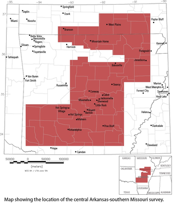
The flyovers will be conducted over all or parts of 50 counties in Arkansas including Boone, Carroll, Marion, Newton, and Searcy and all or parts of 10 counties in southern Missouri including Ozark, Stone, and Taney. The planes and crew will be initially based out of the Branson Airport.
The full release from the USGS is below:
HOLLISTER, Missouri — Scientists with the U.S. Geological Survey (USGS), the Arkansas Geological Survey and the Missouri Geological Survey are partnering to collect geology data using airborne geophysical technology as part of the USGS Earth Mapping Resource Initiative (Earth MRI). Weather permitting, the survey is slated to begin in early November and be completed in the Spring of 2023. None of the instruments carried on the aircraft pose a health risk to people or animals.
The USGS is contracting with Woolpert in collaboration with EON Geosciences who will be conducting the survey to fly over all or parts of 50 counties in central Arkansas and all or parts of 10 counties in southern Missouri. The planes and crew will be initially based out of the Branson airport in Hollister, Missouri.
The survey will collect data that will be publicly available and used by the USGS and state geological surveys to modernize our understanding of the nation’s geologic framework through new 3D models and geologic maps. These products will allow for a better understanding of the distribution of groundwater, mineral and energy resources and the potential for natural hazards. The survey will also support a national-scale effort to acquire modern, high-resolutiuon airborne magnetic and radiometric data across the nation. These efforts replace existing low-quality geophysical data that were collected mostly in the 1980s.
This effort will use the latest technological developments to acquire high-resolution geophysical data that scientists will use to image the geology at the surface and below ground. Up to three Piper Navajo airplanes and one Piper Cheyenne airplane will be actively collecting data in different parts of the survey area.
Each aircraft will be mounted with passive sensors that measure variations in Earth’s natural magnetic field created by different rock types up to several miles beneath the surface. The magnetic sensor will be mounted in a tail stinger off the back of the aircraft. Each plane will also include sensors inside the aircraft that measure soil and rock chemistry at the surface. The aircraft will be flown by experienced pilots that are specially trained and approved for low-level flying. All flights are coordinated with the FAA to ensure flights are in accordance with U.S. law.
The central Arkansas-southern Missouri survey will be flown at elevations of approximately 80 to 300 meters, or about 260 to 1000 feet, above ground in a grid pattern along north-south flight lines spaced approximately 300 meters, or 1000 feet, apart. East-west flight lines will be spaced 3000 meters, or 9800 feet, apart. All survey flights will occur during daylight hours.
The Earth MRI-funded survey is designed to merge with several other magnetic and radiometric surveys collected by the USGS since 2016. Once the central Arkansas and southern Missouri survey is complete, the compilation of the previous surveys with data from this survey will provide the public with the largest continuous swath of high-resolution airborne magnetic and radiometric data in the US.
Earth MRI is a cooperative effort between the USGS, the Association of American State Geologists, and other Federal, State, and private sector organizations to improve our knowledge of the geologic framework in the United States.
 August Begins Below Normal Temperatures
 Ozarks Tech Hosts Open Houses on Area Campuses
 Drought Levels Stay Steady in the Ozarks
 Update on Ribbon Cutting for Re-Opening of Downtown Harrison Bridge
 CHANGES at HUMANE SOCIETY


